About the system
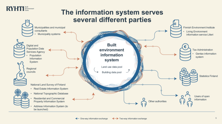
The built environment information system (Ryhti) is a new nation-level information system for Finland. It brings together in one place the land use and construction data from the information systems of municipalities and central government authorities, making this information easy to access.
The new information system is currently being built. Its first services have been completed and implemented in use. Municipalities and regional councils will start providing data to the system gradually, no later than the beginning of 2029.
The Finnish Environment Institute is responsible for developing and maintaining the system. The new approach will bring greater ease and clarity to information management of the national built environment.
Why is this information system being built?
At the moment, detailed data on the built environment is scattered, inconsistent and difficult to access.
The data is spread across many different systems, and it is difficult to access because it is stored in different formats, contains gaps, and the systems themselves are sometimes mutually incompatible.
Information management for the built environment is therefore being reformed so that data on area use and construction will be more easily available and provided in a standardised format. The new operating model will be based on jointly agreed information structures, legislation, and having the information available in one place.
Data to support many official tasks
The built environment continuously generates valuable data that can be used to improve the functionality of our living environment. We need data on matters such as the health, safety, and energy efficiency of the environment and any foreseeable changes to the environment. Data plays a key role in building sustainable living environments and helps prepare for environmental crises.
In the future, information on building permits and planning regulations across the whole country will be available to those who need it in a machine-readable and secure format.
Connected to key government systems
The built environment information system will be integrated into the Government’s overall information management system, whose other components include, for example, the property, population and business information system. The built environment information system is designed to connect with other systems so that each one can retrieve information from the others. The aim is that state actors will only need to make each information request once.
In the future, the core data on land use and buildings (e.g. purpose of use, building rights) will be available only in this new system – from where it can be retrieved by other state information systems or other organisations requiring the information. At the same time, the new information system will utilise information from other systems, such as property, apartment and owner data.

Ryhti brings together national data resources
2019 saw the creation of improved opportunities for national development through the provision of funding linked to the Finnish Government Programme. The digitalisation of the built environment in Finland is being carried forward by the Ryhti project, which runs from 2020 to 2025. The budget for the Ryhti project has been set at EUR 21.9 million. This investment will pay itself back as the data management system develops.
The data must be interoperable so that it can be transmitted in a machine-readable format and can be interpreted in the same way by both sender and the recipient. As part of the Ryhti project, work is being carried out to develop built environment information interoperability by defining an interoperable data format.
In the future, the information resulting from land use planning and construction permit processes will be made available in a standardised format. To this end, the Ryhti national built environment information system is being constructed through broad cooperation.
The system is designed in such a way that content can be added to it later on and new links can be created with other systems. The work to digitalise the built environment will continue after the end of the Ryhti project.